Make a donation
Gear up for your next adventure:
As an Amazon Associate, this site earns from qualifying purchases at no extra cost to you.
Greysouthen topographic map
Click on the map to display elevation.
Make a donation
Gear up for your next adventure:
As an Amazon Associate, this site earns from qualifying purchases at no extra cost to you.
About this map
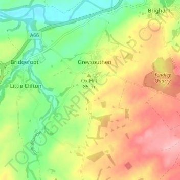
Name: Greysouthen topographic map, elevation, terrain.
Location: Greysouthen, Allerdale, Cumbria, England, United Kingdom (54.62595 -3.46375 54.66106 -3.42201)
Average elevation: 80 m
Minimum elevation: 20 m
Maximum elevation: 147 m
Make a donation
Gear up for your next adventure:
As an Amazon Associate, this site earns from qualifying purchases at no extra cost to you.
Other topographic maps
Click on a map to view its topography, its elevation and its terrain.
Make a donation
Gear up for your next adventure:
As an Amazon Associate, this site earns from qualifying purchases at no extra cost to you.
Mealsgate
United Kingdom > England > Cumbria > Allerdale > Mealsgate > Fletchertown
Average elevation: 104 m
Milefortlet 9, Skinburness
United Kingdom > England > Cumbria > Allerdale > Skinburness
Average elevation: 3 m
Make a donation
Gear up for your next adventure:
As an Amazon Associate, this site earns from qualifying purchases at no extra cost to you.
Oughterby
United Kingdom > England > Cumbria > Allerdale > Kirkbampton > Oughterby
Average elevation: 35 m
Make a donation
Gear up for your next adventure:
As an Amazon Associate, this site earns from qualifying purchases at no extra cost to you.
