
Mount Bromo topographic map
Click on the map to display elevation.
About this map
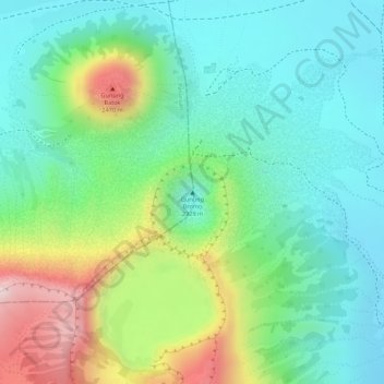
Name: Mount Bromo topographic map, elevation, terrain.
Location: Mount Bromo, Pasuruan, Indonesia (-7.94212 112.95293 -7.94202 112.95303)
Average elevation: 2,239 m
Minimum elevation: 2,110 m
Maximum elevation: 2,504 m
Other topographic maps
Click on a map to view its topography, its elevation and its terrain.
Special Capital Region of Jakarta
Jakarta lies in a low and flat alluvial plain, ranging from −2 to 91 m (−7 to 299 ft) with an average elevation of 8 m (26 ft) above sea level with historically extensive swampy areas. Some parts of the city have been constructed on reclaimed tidal flats that occur in around the area. Thirteen rivers flow…
Average elevation: 5 m
Pulau Bali
Bali features a diverse topography shaped by a volcanic origin, which significantly influences its landscapes and climate. The island is dominated by a central mountain range that runs from west to east, with Mount Agung, reaching an elevation of approximately 10,308 feet, standing as the highest peak and a…
Average elevation: 122 m
East Java
East Java has a tropical monsoon and savanna climate at lower elevation and subtropical at higher elevation. Compared with the western part of Java Island, East Java in general has less rainfall. Average rainfall is 1,900 mm per year, with a rainy season during the 100 days. The average temperature ranges…
Average elevation: 62 m
Semarang
Semarang is located on the northern coast of Java. The city of Semarang is one of the important cities located on the north coast of Java and as the main hub connecting Jakarta and Surabaya, and cities in the southern interior of Java Surakarta and Yogyakarta. Semarang City has a height ranging from 2 m (6.6…
Average elevation: 107 m
Bali
Bali's central mountains include several peaks over 2,000 metres (6,600 feet) in elevation and active volcanoes such as Mount Batur. The highest is Mount Agung (3,031 m, 9,944 ft), known as the "mother mountain", which is an active volcano rated as one of the world's most likely sites for a massive eruption…
Average elevation: 88 m
Bandung City
Bandung (Sundanese: ᮘᮔ᮪ᮓᮥᮀ, romanized: Bandung, Sundanese pronunciation: [ˈbandʊŋ]; /ˈbɑːndʊŋ/) is the capital city of the Indonesian province of West Java. It has a population of 2,452,943 within its city limits according to the official estimates as at mid 2021, making it the fourth most…
Average elevation: 830 m
East Java
East Java has a tropical monsoon and savanna climate at lower elevation and subtropical at higher elevation. Compared with the western part of Java Island, East Java in general has less rainfall. Average rainfall is 1,900 mm per year, with a rainy season during the 100 days. The average temperature ranges…
Average elevation: 62 m
Lombok
Indonesia > West Nusa Tenggara
The island's topography is dominated by the centrally-located stratovolcano Mount Rinjani, the second-highest volcano in Indonesia, which rises to 3,726 metres (12,224 ft), making Lombok the 8th-highest island. The most recent eruption of Rinjani occurred in September 2016 at Gunung Barujari. In a 2010…
Average elevation: 192 m
Wonosobo
Wonosobo has an elevation moderated tropical rainforest climate (Af) with moderate rainfall from July to September and heavy to very heavy rainfall in the remaining months. The following climate data is for the town of Wonosobo.
Average elevation: 876 m
Brebes
The first six districts in the table below are the most southerly, and are generally highlands, reaching an altitude of 875 metres in Sirampog District, while the remaining eleven districts are more northerly and generally lower-lying, and have a higher population density, reaching over 2,000 persons per km2…
Average elevation: 232 m
Banda Aceh
Banda Aceh (/bʌndəˈɑːtʃeɪ/ BUN-duh-AH-cheh; Acehnese: Banda Acèh, Jawoe: بند اچيه) is the capital and largest city in the province of Aceh, Indonesia. It is located on the island of Sumatra and has an elevation of 35 metres (115 ft). The city covers an area of 61.36 square kilometers (23.69 sq…
Average elevation: 5 m
Makassar
Makassar City is a city located near the coast that stretches along the western and northern corridors and is also known as the "Waterfront City" which contains several rivers such as the Tallo River, Jeneberang River, and Pampang River) all of which flow into the city. Makassar City is a stretch of lowland at…
Average elevation: 13 m
Bekasi
The City of Bekasi is a part of the Bekasi river basin, located in the downstream area of the basin with slopes ranging from 0 to 2% and elevations between 11 meters to 81 meters above sea level. The city of Bekasi is part of the Bekasi river basin and is located in the downstream area of the basin, with a…
Average elevation: 32 m
Temanggung
Temanggung Regency is located on the volcanic Dieng Plateau with an average elevation between 500 and 1450 meters. It is landlocked. The volcanoes Mount Sundoro and Mount Sumbing rise on its border with the Wonosobo Regency. Its major drainage system is the Progo River and its tributaries.
Average elevation: 771 m
Lombok
Indonesia > West Nusa Tenggara
The island's topography is dominated by the centrally located stratovolcano Mount Rinjani, the second-highest volcano in Indonesia, which rises to 3,726 metres (12,224 ft), making Lombok the 8th-highest island. The most recent eruption of Rinjani occurred in September 2016 at Gunung Barujari. In a 2010…
Average elevation: 192 m
Kendari
Indonesia > Southeast Sulawesi
Kendari borders the Konawe Regency in the north, South Konawe Regency in the south and west, and Kendari Bay (an inlet from the Banda Sea) in the east. The city is on the southeastern part of mainland Sulawesi island; several smaller islands around Kendari Bay are within its boundaries. The city's topography…
Average elevation: 67 m
Java
Java is an island with a large amount of biodiversity. The natural environment of Java is tropical rainforest, with ecosystems ranging from coastal mangrove forest on the north coast, rocky coastal cliffs on the southern coast, and low-lying tropical forest to high altitude rainforest on the slopes of…
Average elevation: 39 m
Borneo
Before sea levels rose at the end of the last Ice Age, Borneo was part of the mainland of Asia, forming, with Java and Sumatra, the upland regions of a peninsula that extended east from present day Indochina. The South China Sea and Gulf of Thailand now submerge the former low-lying areas of the peninsula.…
Average elevation: 141 m
Blangkejeren
Blangkejeren is located in the upper reaches of the Tripa River Basin, at an elevation of approximately 920 metres above sea level. It is a highland town nestled in the Bukit Barisan mountain range of Sumatra.
Average elevation: 1,403 m
Bali
Bali's central mountains include several peaks over 2,000 metres (6,600 feet) in elevation and active volcanoes such as Mount Batur. The highest is Mount Agung (3,031 m; 9,944 ft), known as the "mother mountain", which is an active volcano rated as one of the world's most likely sites for a massive eruption…
Average elevation: 88 m
Playen
Indonesia > Special Region of Yogyakarta > Gunungkidul Regency > Playen
Average elevation: 182 m
Mount Gede Pangrango National Park
Indonesia > West Java > Sukabumi > Kadudampit
Average elevation: 1,055 m
Tabanan
The topography of this regency is located between an altitude of 0 - 2,276 meters above sea level, with details; at an altitude of 0 – 500 meters above sea level is a flat area with a slope of 2 - 15%. Meanwhile, at an altitude of 500-1,000 meters above sea level, it is a flat to sloping area with a slope of…
Average elevation: 412 m
Tangerang
Topographically, Tangerang City is mostly located at an altitude of 10-30 meters above sea level, aka the whole area is in the lowlands. The northern part of the city (covering most of Benda District) has an average height of 10 meters above sea level, while the southern part of Tangerang City has a height of…
Average elevation: 16 m
Megamendung
Much of the district lies at an elevation of 500-600 metres, which moderates the temperature, and causing contrast to the heat of Greater Jakarta and other adjacent low-lying lands. Though much of the built-up area is not necessarily on rugged terrain, uneven ground is the most common terrain as it stands…
Average elevation: 738 m