
Pampore topographic map
Click on the map to display elevation.
About this map
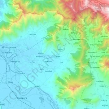
Name: Pampore topographic map, elevation, terrain.
Location: Pampore, Pulwama District, Jammu and Kashmir, 191102, India (33.92882 74.90524 34.11682 75.09093)
Average elevation: 2,015 m
Minimum elevation: 1,583 m
Maximum elevation: 3,720 m
Other topographic maps
Click on a map to view its topography, its elevation and its terrain.
Khrew
India > Jammu and Kashmir > Pampore
Khrew is located at 34°01′12″N 74°59′24″E / 34.020°N 74.99°E / 34.020; 74.99. It has an average elevation of 1,607 metres (5,272 feet) and is located in the Kashmir valley. The area starts from Babapora to Seer Bagh and from Bathen to Androosa. Also, the foot region is extended to Ladhoo,…
Average elevation: 1,788 m