Geolocate

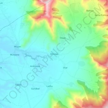
Khrew topographic map

Click on the map to display elevation.

Khrew

Khrew is located at 34°01′12″N 74°59′24″E / 34.020°N 74.99°E / 34.020; 74.99. It has an average elevation of 1,607 metres (5,272 feet) and is located in the Kashmir valley. The area starts from Babapora to Seer Bagh and from Bathen to Androosa. Also, the foot region is extended to Ladhoo, a village in Jammu and Kashmir.

Wikipedia (CC-BY-SA 3.0)

About this map

Name: Khrew topographic map, elevation, terrain.

Location: Khrew, Pampore, Pulwama District, Jammu and Kashmir, 191102, India (33.97985 74.95954 34.05985 75.03954)

Average elevation: 1,788 m

Minimum elevation: 1,589 m

Maximum elevation: 2,493 m

Other topographic maps

Click on a map to view its topography, its elevation and its terrain.
Pampore

India > Jammu and Kashmir > Pampore

Average elevation: 2,015 m

Gear up for your next adventure:

🥾Hiking Gaiters - Protect legs and shoes from mud, snow, and debris
💧Filtered Water Bottle - Safe drinking water on the go
🔦LED Headlamp - Hands-free lighting for early morning starts or late finishes
🧊Insulated Water Bottle - Keeps drinks cold in summer and prevents freezing in winter
🧴Outdoor Sunscreen - High SPF protection for high-altitude UV exposure

As an Amazon Associate, this site earns from qualifying purchases at no extra cost to you.