
Abbotsford topographic map
Click on the map to display elevation.
About this map
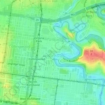
Name: Abbotsford topographic map, elevation, terrain.
Location: Abbotsford, Melbourne, Victoria, 3067, Australia (-37.81214 144.99137 -37.79529 145.01584)
Average elevation: 25 m
Minimum elevation: 6 m
Maximum elevation: 64 m
Other topographic maps
Click on a map to view its topography, its elevation and its terrain.
Narre Warren North Retarding Basin (Melbourne Water)
Australia > Victoria > Melbourne
Average elevation: 76 m
Mount Dandenong
Australia > Victoria > Melbourne
Mount Dandenong has a cool oceanic climate (Cfb), with cool to mild summers and cold, damp winters. Daytime temperatures are usually 4−6 °C cooler than downtown Melbourne due to its elevation and distance from the urban heat island effect of Melbourne. It is significantly cloudier than Melbourne,…
Average elevation: 395 m
Gilbertsons Grassland Nature Conservation Reserve
Australia > Victoria > Melbourne
Average elevation: 36 m
Yarra Valley
Australia > Victoria > Melbourne
The Yarra Valley is the region surrounding the Yarra River in Victoria, Australia. The river originates approximately 240 km (150 mi) east of the Melbourne central business district and flows towards it and out into Port Phillip Bay. The name Yarra Valley is used in reference to the upper regions surrounding…
Average elevation: 305 m
Langwarrin Flora and Fauna Reserve
Australia > Victoria > Melbourne > Langwarrin
Average elevation: 90 m