
Whitesburg topographic map
Interactive map
Click on the map to display elevation.
About this map
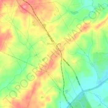
Name: Whitesburg topographic map, elevation, terrain.
Location: Whitesburg, Carroll County, Georgia, United States (33.47139 -84.94015 33.50910 -84.89310)
Average elevation: 249 m
Minimum elevation: 206 m
Maximum elevation: 292 m
Other topographic maps
Click on a map to view its topography, its elevation and its terrain.
Carrollton
United States > Georgia > Carroll County
Carrollton, Carroll County, Georgia, United States
Average elevation: 329 m
Roopville
United States > Georgia > Carroll County
Roopville, Carroll County, Georgia, United States
Average elevation: 350 m
Bowdon
United States > Georgia > Carroll County
Bowdon, Carroll County, Georgia, 30108, United States
Average elevation: 319 m
Mount Zion
United States > Georgia > Carroll County
Mount Zion, Carroll County, Georgia, United States
Average elevation: 356 m
Ithaca
United States > Georgia > Carroll County
Ithaca, Carroll County, Georgia, United States
Average elevation: 342 m
Villa Rica
United States > Georgia > Carroll County
Villa Rica, Carroll County, Georgia, 30180, United States
Average elevation: 338 m
Lowell
United States > Georgia > Carroll County
Lowell, Carroll County, Georgia, United States
Average elevation: 304 m
Temple
United States > Georgia > Carroll County
Temple, Carroll County, Georgia, United States
Average elevation: 346 m