Geolocate

Lowell topographic map

Click on the map to display elevation.

About this map

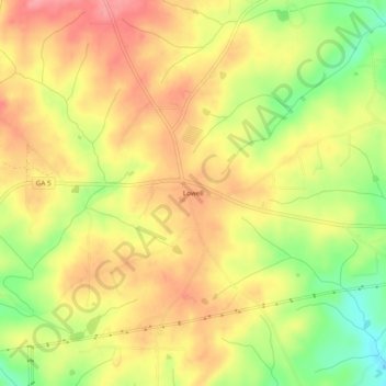
Name: Lowell topographic map, elevation, terrain.

Location: Lowell, Carroll County, Georgia, United States (33.44650 -85.06494 33.48650 -85.02494)

Average elevation: 304 m

Minimum elevation: 245 m

Maximum elevation: 346 m

Other topographic maps

Click on a map to view its topography, its elevation and its terrain.

Mount Zion

United States > Georgia > Carroll County

Average elevation: 356 m

Roopville

United States > Georgia > Carroll County

Average elevation: 350 m

Temple

United States > Georgia > Carroll County

Average elevation: 346 m

Roopville

United States > Georgia > Carroll County

Average elevation: 350 m

Gear up for your next adventure:

🧥Waterproof Hiking Jacket - Protect yourself from rain and wind while hiking
🛰️Satellite Messenger - Emergency communication for areas with no cell service
🔦LED Headlamp - Hands-free lighting for early morning starts or late finishes
💡LED Camping Lantern - Illuminate your campsite with long-lasting lanterns
💧Reusable Water Bottle - Durable water bottles for hydration on trails

As an Amazon Associate, this site earns from qualifying purchases at no extra cost to you.