Geolocate

Mount Zion topographic map

Click on the map to display elevation.

About this map

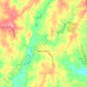
Name: Mount Zion topographic map, elevation, terrain.

Location: Mount Zion, Carroll County, Georgia, United States (33.60884 -85.20707 33.67039 -85.14784)

Average elevation: 356 m

Minimum elevation: 307 m

Maximum elevation: 404 m

Other topographic maps

Click on a map to view its topography, its elevation and its terrain.

Clem

United States > Georgia > Carroll County

Average elevation: 337 m

Lowell

United States > Georgia > Carroll County

Average elevation: 304 m

Ithaca

United States > Georgia > Carroll County

Average elevation: 342 m

Roopville

United States > Georgia > Carroll County

Average elevation: 350 m

Cross Plains

United States > Georgia > Carroll County

Average elevation: 316 m

Gear up for your next adventure:

🧥Thermal Fleece Jacket - Versatile insulation for changing mountain temperatures
🥾Waterproof Hiking Boots - Boots keeping your feet dry in wet conditions
🔭Outdoor Binoculars - Lightweight binoculars for birdwatching and hiking
🥾Trail Hiking Boots - Supportive boots for rough trails
🚲Handlebar Phone Mount - View topographic-map.com live while cycling

As an Amazon Associate, this site earns from qualifying purchases at no extra cost to you.