Geolocate

Tumtum topographic map

Click on the map to display elevation.

About this map

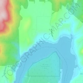
Name: Tumtum topographic map, elevation, terrain.

Location: Tumtum, Stevens County, Washington, United States (47.87156 -117.70301 47.91156 -117.66301)

Average elevation: 555 m

Minimum elevation: 464 m

Maximum elevation: 881 m

Other topographic maps

Click on a map to view its topography, its elevation and its terrain.

Valley

United States > Washington > Stevens County > Valley

Average elevation: 555 m

Addy

United States > Washington > Stevens County > Addy

Average elevation: 603 m

Loon Lake

United States > Washington > Stevens County

Average elevation: 779 m

Kettle Falls

United States > Washington > Stevens County

Average elevation: 508 m

Valley

United States > Washington > Stevens County > Valley

Average elevation: 555 m

Loon Lake

United States > Washington > Stevens County

Average elevation: 779 m

Kettle Falls

United States > Washington > Stevens County

Average elevation: 508 m

Colville

United States > Washington > Stevens County

Average elevation: 559 m

Chewelah

United States > Washington > Stevens County

Average elevation: 590 m

Springdale

United States > Washington > Stevens County

Average elevation: 656 m

Colville

United States > Washington > Stevens County

Average elevation: 559 m

Northport

United States > Washington > Stevens County

Average elevation: 500 m

Springdale

United States > Washington > Stevens County

Average elevation: 656 m

Northport

United States > Washington > Stevens County

Average elevation: 502 m

Gear up for your next adventure:

🧢Beanie Hat - Keep your head warm in cold weather
👖Convertible Hiking Pants - Zip-off legs to adapt to changing weather conditions
🌬️Windproof Camp Stove - Efficient cooking even on exposed mountain peaks
🧥Insulated Jacket - Keep warm in cold outdoor conditions
🔨Vehicle Emergency Tool - Safety tool for remote road trips to trailheads

As an Amazon Associate, this site earns from qualifying purchases at no extra cost to you.