Geolocate

Ongko topographic map

Click on the map to display elevation.

About this map

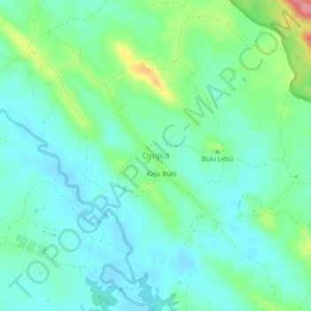
Name: Ongko topographic map, elevation, terrain.

Location: Ongko, Enrekang, South Sulawesi, Sulawesi, Indonesia (-3.78172 119.87914 -3.74172 119.91914)

Average elevation: 70 m

Minimum elevation: 43 m

Maximum elevation: 151 m

Other topographic maps

Click on a map to view its topography, its elevation and its terrain.

Baraka

Indonesia > South Sulawesi > Enrekang

Average elevation: 827 m

Bungin

Indonesia > South Sulawesi > Enrekang

Average elevation: 1,238 m

Buntu Batu

Indonesia > South Sulawesi > Enrekang

Average elevation: 1,459 m

Cendana

Indonesia > South Sulawesi > Enrekang

Average elevation: 152 m

Maiwa

Indonesia > South Sulawesi > Enrekang

Average elevation: 214 m

Malua

Indonesia > South Sulawesi > Enrekang

Average elevation: 709 m

Malua

Indonesia > South Sulawesi > Enrekang

Average elevation: 709 m

Alla

Indonesia > South Sulawesi > Enrekang

Average elevation: 1,037 m

Gear up for your next adventure:

🛁Quick-Dry Microfiber Towel - Space-saving towel that dries rapidly on the move
🔦LED Headlamp - Hands-free lighting for early morning starts or late finishes
🥾Durable Hiking Shoes - Long-lasting shoes for frequent hiking
🧢Sun Hat - Wide-brim hat for sun protection
🥾Trekking Poles - Adjustable trekking poles to reduce knee stress and improve stability

As an Amazon Associate, this site earns from qualifying purchases at no extra cost to you.