Geolocate

Camdenton topographic map

Click on the map to display elevation.

About this map

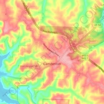
Name: Camdenton topographic map, elevation, terrain.

Location: Camdenton, Camden County, Missouri, United States (37.98606 -92.78764 38.03684 -92.71483)

Average elevation: 272 m

Minimum elevation: 202 m

Maximum elevation: 323 m

Other topographic maps

Click on a map to view its topography, its elevation and its terrain.

Roach

United States > Missouri > Camden County

Average elevation: 263 m

Wet Glaize

United States > Missouri > Camden County

Average elevation: 274 m

Damsel

United States > Missouri > Camden County > Osage Beach

Average elevation: 231 m

Gear up for your next adventure:

🧥Fleece Jacket - Warm and lightweight jacket for layering
🛶Kayak Accessories - Essential gear for safe and fun kayaking adventures
🛏️Sleeping Bag - Warm and compact sleeping bags for outdoor camping
Camping Groundsheet - Protect your tent from moisture and dirt
💧Hydration Pack - Hands-free hydration system for long hikes

As an Amazon Associate, this site earns from qualifying purchases at no extra cost to you.