Geolocate

Weyers Cave topographic map

Click on the map to display elevation.

About this map
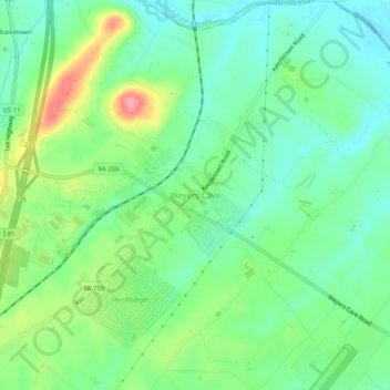
Name: Weyers Cave topographic map, elevation, terrain.

Location: Weyers Cave, Augusta County, Virginia, 24486, United States (38.26617 -78.93090 38.30617 -78.89090)

Average elevation: 361 m

Minimum elevation: 328 m

Maximum elevation: 427 m

Other topographic maps

Click on a map to view its topography, its elevation and its terrain.

Greenville

United States > Virginia > Augusta County > Greenville

Average elevation: 508 m

Crimora

United States > Virginia > Augusta County > Crimora

Average elevation: 409 m

Lyndhurst

United States > Virginia > Augusta County > Lyndhurst

Average elevation: 446 m

Deerfield

United States > Virginia > Augusta County

Average elevation: 585 m

Stuarts Draft

United States > Virginia > Augusta County

Stuarts Draft includes several natural and man-made ponds. Lake Wilda is Green Pond is a naturally occurring high-elevation pond on the Big Levels Ridge. It is five acres in size during the wet season. The Virginia Commission of Game and Inland Fisheries constructed the Maple Flats Ponds in the late 1950s to…

Average elevation: 457 m

Lyndhurst

United States > Virginia > Augusta County > Lyndhurst

Average elevation: 437 m

Gear up for your next adventure:

⛺Lightweight Camping Tent - Portable shelter optimized for Canadian backcountry camping
🎒Fully Waterproof Backpack - Total protection for photography gear and electronics
🧦Outdoor Socks - Durable socks designed for hiking and outdoor sports
🥾Trail Hiking Shoes - Durable shoes designed for rugged trails
🧴Bear Spray Holster - Quick-access carry for essential Canadian wilderness safety

As an Amazon Associate, this site earns from qualifying purchases at no extra cost to you.