Geolocate

Greenville topographic map

Click on the map to display elevation.

About this map

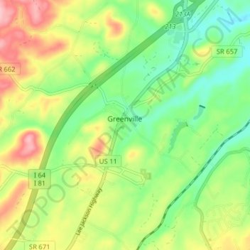
Name: Greenville topographic map, elevation, terrain.

Location: Greenville, Augusta County, Virginia, 24440, United States (37.97928 -79.17852 38.02511 -79.11444)

Average elevation: 508 m

Minimum elevation: 447 m

Maximum elevation: 597 m

Gear up for your next adventure:

🛶Canoe Life Vest - Safety vest for water sports
🦶Anti-Blister Balm - Prevents friction and hotspots during long ascents
🧴Sunscreen SPF - Broad-spectrum sunscreen for outdoor activities
💡Compact LED Flashlight - Powerful and portable flashlight for outdoor use
🥾Trail Hiking Shoes - Durable shoes designed for rugged trails

As an Amazon Associate, this site earns from qualifying purchases at no extra cost to you.