Geolocate

Xingning District topographic map

Click on the map to display elevation.

About this map

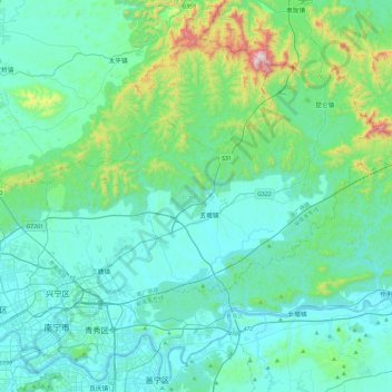
Name: Xingning District topographic map, elevation, terrain.

Location: Xingning District, Nanning, Guangxi, China (22.81576 108.30849 23.10930 108.77638)

Average elevation: 191 m

Minimum elevation: 56 m

Maximum elevation: 994 m

Other topographic maps

Click on a map to view its topography, its elevation and its terrain.

Gulan

China > Guangxi > Nanning

Average elevation: 225 m

Bolang

China > Guangxi > Nanning

Average elevation: 99 m

Tandun

China > Guangxi > Nanning

Average elevation: 124 m

Bahong

China > Guangxi > Nanning

Average elevation: 129 m

Kunlun

China > Guangxi > Nanning > Kunlun

Average elevation: 256 m

Gear up for your next adventure:

🧣Evaporative Cooling Towel - Beat the heat during intense summer climbs
🧢Beanie Hat - Keep your head warm in cold weather
👟Trail Running Shoes - Agile footwear for fast-paced topographic exploration
❄️Traction Ice Cleats - Slip-on spikes for icy trails and winter hiking
🔭Compact Monocular - One-handed bird watching and trail spotting

As an Amazon Associate, this site earns from qualifying purchases at no extra cost to you.