Geolocate

Gulan topographic map

Click on the map to display elevation.

About this map

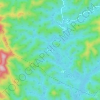
Name: Gulan topographic map, elevation, terrain.

Location: Gulan, Nanning, Guangxi, China (23.01045 108.51447 23.05045 108.55447)

Average elevation: 225 m

Minimum elevation: 157 m

Maximum elevation: 436 m

Other topographic maps

Click on a map to view its topography, its elevation and its terrain.

Long'an County

China > Guangxi > Nanning

Average elevation: 255 m

Yongning District

China > Guangxi > Nanning

Average elevation: 118 m

Qingxiu District

China > Guangxi > Nanning

Average elevation: 140 m

Liangqing

China > Guangxi > Nanning

Average elevation: 98 m

Xingning District

China > Guangxi > Nanning

Average elevation: 191 m

Heng County

China > Guangxi > Nanning

Average elevation: 135 m

Gear up for your next adventure:

Lightweight Camping Tent - Portable shelter optimized for Canadian backcountry camping
🥾Trail Hiking Socks - Comfortable socks to prevent blisters and fatigue
🥾Mountain Hiking Shoes - Shoes with superior grip for mountainous terrain
🔦LED Flashlight - Powerful and long-lasting flashlight for camping and emergencies
Backpacking Tent - Lightweight tent for long-distance hiking trips

As an Amazon Associate, this site earns from qualifying purchases at no extra cost to you.