Geolocate

Dodford topographic map

Click on the map to display elevation.

About this map

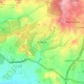
Name: Dodford topographic map, elevation, terrain.

Location: Dodford, Bromsgrove, Worcestershire, England, B61 9BU, United Kingdom (52.33531 -2.12338 52.37531 -2.08338)

Average elevation: 116 m

Minimum elevation: 61 m

Maximum elevation: 183 m

Other topographic maps

Click on a map to view its topography, its elevation and its terrain.

Romsley CP

United Kingdom > England > Worcestershire > Bromsgrove

Average elevation: 205 m

Wythall CP

United Kingdom > England > Worcestershire > Bromsgrove

Average elevation: 155 m

Wythall CP

United Kingdom > England > Worcestershire > Bromsgrove

Average elevation: 155 m

Wythall CP

United Kingdom > England > Worcestershire > Bromsgrove

Average elevation: 155 m

Clent

United Kingdom > England > Worcestershire > Bromsgrove

Because of the hilly topography of the parish the village consists of several distinct hamlets. These are Upper Clent (Clatterbach and the area around the parish church of St. Leonard), Lower Clent, Holy Cross, Adams Hill and Walton Pool. The Civil Parish of Clent also included part of the village of West…

Average elevation: 184 m

Romsley CP

United Kingdom > England > Worcestershire > Bromsgrove

Average elevation: 205 m

Wythall CP

United Kingdom > England > Worcestershire > Bromsgrove

Average elevation: 155 m

Gear up for your next adventure:

🔭Compact Binoculars - Lightweight optics for scouting trails and wildlife
🥾Light Hiking Boots - Lightweight and comfortable boots for day hikes
🦟Insect Repellent - Keep mosquitoes and black flies away in wooded areas
🧴Bear Spray Holster - Quick-access carry for essential Canadian wilderness safety
🌡️Emergency Mylar Blankets - Compact thermal protection for unexpected nights outdoors

As an Amazon Associate, this site earns from qualifying purchases at no extra cost to you.