Geolocate

Omaha topographic map

Click on the map to display elevation.

About this map

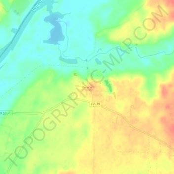
Name: Omaha topographic map, elevation, terrain.

Location: Omaha, Stewart County, Georgia, 31821, United States (32.12626 -85.03326 32.16626 -84.99326)

Average elevation: 78 m

Minimum elevation: 53 m

Maximum elevation: 107 m

Other topographic maps

Click on a map to view its topography, its elevation and its terrain.

Richland

United States > Georgia > Stewart County

Average elevation: 162 m

Lumpkin

United States > Georgia > Stewart County

Average elevation: 147 m

Gear up for your next adventure:

🛏️Sleeping Bag - Warm and compact sleeping bags for outdoor camping
🔭Compact Binoculars - Lightweight optics for scouting trails and wildlife
🧤Insulated Winter Gloves - Heavy-duty protection for sub-zero Canadian adventures
💧Hydration Pack - Hands-free hydration system for long hikes
🧴Waterproofing Spray - Restore the DWR coating on jackets and tents

As an Amazon Associate, this site earns from qualifying purchases at no extra cost to you.