Geolocate

Lumpkin topographic map

Click on the map to display elevation.

About this map

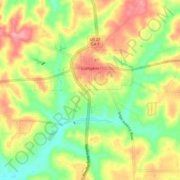
Name: Lumpkin topographic map, elevation, terrain.

Location: Lumpkin, Stewart County, Georgia, United States (32.02680 -84.82972 32.05909 -84.75103)

Average elevation: 147 m

Minimum elevation: 102 m

Maximum elevation: 194 m

Other topographic maps

Click on a map to view its topography, its elevation and its terrain.

Omaha

United States > Georgia > Stewart County

Average elevation: 78 m

Lumpkin

United States > Georgia > Stewart County > Lumpkin > Lumpkin

Average elevation: 147 m

Gear up for your next adventure:

🔋Lithium AA Batteries - Long-lasting power that performs in extreme cold
❄️Traction Ice Cleats - Slip-on spikes for icy trails and winter hiking
🧭GPS Handheld Device - Reliable GPS navigation for outdoor adventures
🧭GPS Tracker - Track your location in remote areas safely
Camping Coffee Maker - Brew fresh coffee anywhere on the topographic map

As an Amazon Associate, this site earns from qualifying purchases at no extra cost to you.