Geolocate

Richland topographic map

Click on the map to display elevation.

About this map

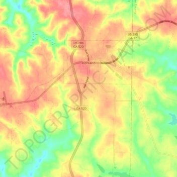
Name: Richland topographic map, elevation, terrain.

Location: Richland, Stewart County, Georgia, 31825, United States (32.05246 -84.74234 32.09879 -84.64277)

Average elevation: 162 m

Minimum elevation: 116 m

Maximum elevation: 198 m

Other topographic maps

Click on a map to view its topography, its elevation and its terrain.

Omaha

United States > Georgia > Stewart County

Average elevation: 78 m

Lumpkin

United States > Georgia > Stewart County > Lumpkin > Lumpkin

Average elevation: 147 m

Gear up for your next adventure:

🛏️Camping Sleeping Mat - Comfortable mats for sleeping outdoors
🥽Outdoor Goggles - Protective eyewear for outdoor activities
🧥Thermal Layer - Insulating layer for cold outdoor conditions
🧥Waterproof Hiking Jacket - Protect yourself from rain and wind while hiking
🧥Waterproof Pants - Keep dry during rainy hiking conditions

As an Amazon Associate, this site earns from qualifying purchases at no extra cost to you.