Geolocate

Piquín topographic map

Click on the map to display elevation.

About this map

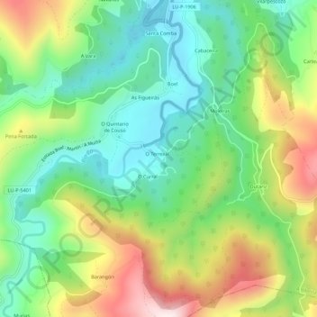
Name: Piquín topographic map, elevation, terrain.

Location: Piquín, Santalla, A Ribeira de Piquín, Meira, Lugo, Galicia, 27244, España (43.13676 -7.22113 43.17676 -7.18113)

Average elevation: 449 m

Minimum elevation: 235 m

Maximum elevation: 813 m

Other topographic maps

Click on a map to view its topography, its elevation and its terrain.

Meira

España > Galicia > Meira

Average elevation: 574 m

A Órrea

España > Galicia > Meira > Riotorto

Average elevation: 526 m

Mosteiro

España > Galicia > Meira > Pol

Average elevation: 513 m

Riotorto

España > Galicia > Meira

Average elevation: 445 m

Galegos

España > Galicia > Meira > Riotorto

Average elevation: 355 m

Pol

España > Galicia > Meira

Las mayores altitudes están hacia el este (Pena Grande, 935m, "Montes da Ferradura", 809 m y Penedo do Pao, 827 m). En los límites con Castro de Rey la altitud apenas supera los 400 m y las Colinas intermedias no superan los 650 m. De ellos parten numerosos arroyos y ríos.

Average elevation: 589 m

Milleirós

España > Galicia > Meira > Pol

Average elevation: 656 m

Meira

España > Galicia > Meira

Average elevation: 574 m

Gear up for your next adventure:

🥾Hiking Leggings - Comfortable leggings for outdoor activities
🧴Waterproofing Spray - Restore the DWR coating on jackets and tents
💡Compact LED Flashlight - Powerful and portable flashlight for outdoor use
🔭Compact Monocular - One-handed bird watching and trail spotting
🌡️Emergency Mylar Blankets - Compact thermal protection for unexpected nights outdoors

As an Amazon Associate, this site earns from qualifying purchases at no extra cost to you.