Geolocate

Pol topographic map

Click on the map to display elevation.

About this map

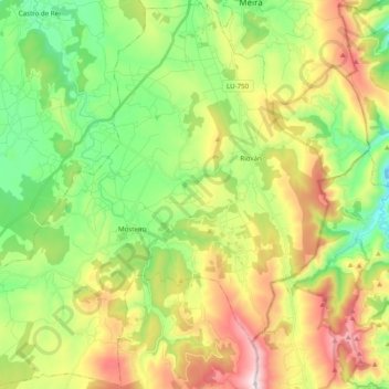
Name: Pol topographic map, elevation, terrain.

Location: Pol, Meira, Lugo, Galicia, Spain (43.07226 -7.43005 43.21333 -7.23384)

Average elevation: 589 m

Minimum elevation: 311 m

Maximum elevation: 1,027 m

Gear up for your next adventure:

Camping Groundsheet - Protect your tent from moisture and dirt
🌬️Windproof Camp Stove - Efficient cooking even on exposed mountain peaks
🦶Hiking Shoe Insoles - Added support for high arches and long days on feet
💡Solar Camping Lamp - Eco-friendly lighting for campsites
🔭Outdoor Binoculars - Lightweight binoculars for birdwatching and hiking

As an Amazon Associate, this site earns from qualifying purchases at no extra cost to you.