
Rosenau topographic map
Interactive map
Click on the map to display elevation.
About this map
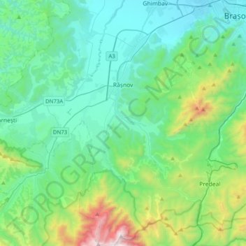
Name: Rosenau topographic map, elevation, terrain.
Location: Rosenau, Zona Metropolitană Brașov, Kronstadt, Rumänien (45.44714 25.39063 45.66601 25.56942)
Average elevation: 918 m
Minimum elevation: 536 m
Maximum elevation: 2,486 m
Weitere Ausflugsziele in der Umgebung sind u. a. das Schloss Bran, der Nationalpark im Piatra-Craiului-Gebirge (Königsteingebirge) sowie das Prahovatal mit den Kurorten in Predeal und in Sinaia. Zum 390 m höheren Wintersportort Poiana Brașov (Schulerau) führt ab unterhalb der Bauernburg eine 12 Kilometer lange Asphaltstraße.
Other topographic maps
Click on a map to view its topography, its elevation and its terrain.