Geolocate

Coello Cocora topographic map

Click on the map to display elevation.

About this map

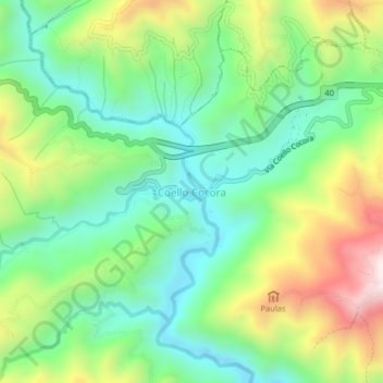
Name: Coello Cocora topographic map, elevation, terrain.

Location: Coello Cocora, Ibagué, Centro, Tolima, Colombia (4.38053 -75.31048 4.42053 -75.27048)

Average elevation: 1,381 m

Minimum elevation: 1,111 m

Maximum elevation: 1,873 m

Gear up for your next adventure:

🥾Hiking Shorts - Breathable shorts suitable for summer hikes
Camping Tent - Weather-resistant tents suitable for 2 to 6 people
🧥Thermal Fleece Jacket - Versatile insulation for changing mountain temperatures
🎒Hiking Backpack - Lightweight and ergonomic backpacks for day hikes or multi-day treks
🕶️Polarized Sunglasses - Reduces glare from snow and water at high elevations

As an Amazon Associate, this site earns from qualifying purchases at no extra cost to you.