Geolocate

Planadas topographic map

Click on the map to display elevation.

About this map

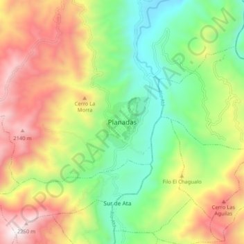
Name: Planadas topographic map, elevation, terrain.

Location: Planadas, Sur, Tolima, Colombia (3.15735 -75.68465 3.23735 -75.60465)

Average elevation: 1,476 m

Minimum elevation: 898 m

Maximum elevation: 2,268 m

Gear up for your next adventure:

🚲Heavy Duty Bike Lock - Secure your bike at the trailhead or during stops
🧭GPS Handheld Device - Reliable GPS navigation for outdoor adventures
🥾Hiking Shoes - Durable and comfortable shoes for trail hiking
🧭GPS Outdoor Watch - Smart watch for navigation and fitness tracking in nature
💧Hydration Pack - Hands-free hydration system for long hikes

As an Amazon Associate, this site earns from qualifying purchases at no extra cost to you.