
Fairmount topographic map
Click on the map to display elevation.
About this map
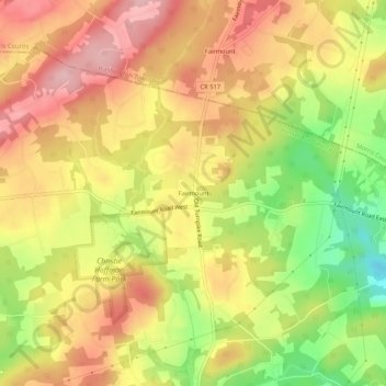
Name: Fairmount topographic map, elevation, terrain.
Average elevation: 236 m
Minimum elevation: 137 m
Maximum elevation: 308 m
Other topographic maps
Click on a map to view its topography, its elevation and its terrain.
Clinton
United States > New Jersey > Hunterdon County
Clinton falls under the North Jersey climate zone. According to the Office of the New Jersey State Climatologist at Rutgers University, the Northern climate zone covers about one-quarter of New Jersey and consists mainly of elevated highlands and valleys which are part of the Appalachian Uplands. Surrounded by…
Average elevation: 74 m
Bethlehem Township
United States > New Jersey > Hunterdon County
Bethlehem Township falls under the "Northern New Jersey" climate zone. According to the Office of the New Jersey State Climatologist at Rutgers University, the Northern climate zone covers about one-quarter of New Jersey and consists mainly of elevated highlands and valleys which are part of the Appalachian…
Average elevation: 160 m
Round Valley Reservoir
United States > New Jersey > Hunterdon County > Clinton Township
Average elevation: 123 m
Clinton
United States > New Jersey > Hunterdon County
Clinton falls under the North Jersey climate zone. According to the Office of the New Jersey State Climatologist at Rutgers University, the Northern climate zone covers about one-quarter of New Jersey and consists mainly of elevated highlands and valleys which are part of the Appalachian Uplands. Surrounded by…
Average elevation: 74 m