
Make a donation
Gear up for your next adventure:
As an Amazon Associate, this site earns from qualifying purchases at no extra cost to you.
Stockton topographic map
Click on the map to display elevation.
Make a donation
Gear up for your next adventure:
As an Amazon Associate, this site earns from qualifying purchases at no extra cost to you.
About this map
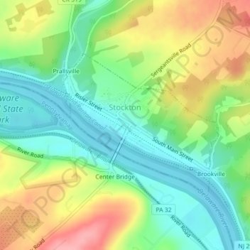
Name: Stockton topographic map, elevation, terrain.
Location: Stockton, Hunterdon County, New Jersey, United States (40.39814 -74.98698 40.41364 -74.96499)
Average elevation: 61 m
Minimum elevation: 15 m
Maximum elevation: 130 m
Make a donation
Gear up for your next adventure:
As an Amazon Associate, this site earns from qualifying purchases at no extra cost to you.
Other topographic maps
Click on a map to view its topography, its elevation and its terrain.
Centerville
United States > New Jersey > Hunterdon County > Readington Township
Average elevation: 49 m
Make a donation
Gear up for your next adventure:
As an Amazon Associate, this site earns from qualifying purchases at no extra cost to you.
Make a donation
Gear up for your next adventure:
As an Amazon Associate, this site earns from qualifying purchases at no extra cost to you.
Wertsville
United States > New Jersey > Hunterdon County > East Amwell Township
Average elevation: 72 m
Whitehouse Station
United States > New Jersey > Hunterdon County > Readington Township
Average elevation: 61 m
Make a donation
Gear up for your next adventure:
As an Amazon Associate, this site earns from qualifying purchases at no extra cost to you.
Rileyville
United States > New Jersey > Hunterdon County > East Amwell Township
Average elevation: 125 m
Make a donation
Gear up for your next adventure:
As an Amazon Associate, this site earns from qualifying purchases at no extra cost to you.
Pleasant Run
United States > New Jersey > Hunterdon County > Readington Township
Average elevation: 63 m
Larisons Corners
United States > New Jersey > Hunterdon County > Larisons Corners
Average elevation: 66 m
Make a donation
Gear up for your next adventure:
As an Amazon Associate, this site earns from qualifying purchases at no extra cost to you.
Make a donation
Gear up for your next adventure:
As an Amazon Associate, this site earns from qualifying purchases at no extra cost to you.