
Milford topographic map
Click on the map to display elevation.
About this map
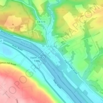
Name: Milford topographic map, elevation, terrain.
Location: Milford, Hunterdon County, New Jersey, United States (40.55633 -75.10300 40.57828 -75.07876)
Average elevation: 84 m
Minimum elevation: 33 m
Maximum elevation: 173 m
Other topographic maps
Click on a map to view its topography, its elevation and its terrain.
Centerville
United States > New Jersey > Hunterdon County > Readington Township
Average elevation: 49 m
Whitehouse Station
United States > New Jersey > Hunterdon County > Readington Township
Average elevation: 61 m
Wertsville
United States > New Jersey > Hunterdon County > East Amwell Township
Average elevation: 72 m
Rileyville
United States > New Jersey > Hunterdon County > East Amwell Township
Average elevation: 125 m
Pleasant Run
United States > New Jersey > Hunterdon County > Readington Township
Average elevation: 63 m
Larisons Corners
United States > New Jersey > Hunterdon County > Larisons Corners
Average elevation: 66 m