Geolocate

Joplin topographic map

Click on the map to display elevation.

About this map

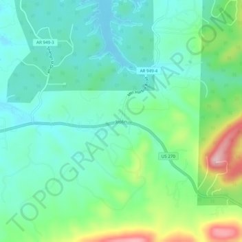
Name: Joplin topographic map, elevation, terrain.

Location: Joplin, Montgomery County, Arkansas, United States (34.52231 -93.47269 34.56231 -93.43269)

Average elevation: 231 m

Minimum elevation: 173 m

Maximum elevation: 389 m

Other topographic maps

Click on a map to view its topography, its elevation and its terrain.

Oden

United States > Arkansas > Montgomery County

Average elevation: 234 m

Mount Ida

United States > Arkansas > Montgomery County

Average elevation: 215 m

Mount Ida

United States > Arkansas > Montgomery County

Average elevation: 215 m

Gear up for your next adventure:

🥾Mountain Trail Shoes - High-traction shoes for mountain trails
🥾Trail Hiking Shoes - Durable shoes designed for rugged trails
🥾Trail Running Boots - Durable shoes designed for trail running
💧Collapsible Water Bottle - Space-saving water bottle for outdoor activities
Family Camping Tent - Spacious tent suitable for family camping trips

As an Amazon Associate, this site earns from qualifying purchases at no extra cost to you.