Geolocate

Oden topographic map

Click on the map to display elevation.

About this map

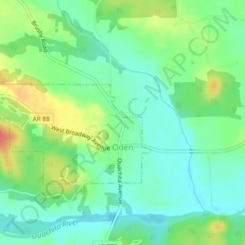
Name: Oden topographic map, elevation, terrain.

Location: Oden, Montgomery County, Arkansas, United States (34.61382 -93.80063 34.62944 -93.77320)

Average elevation: 234 m

Minimum elevation: 214 m

Maximum elevation: 270 m

Other topographic maps

Click on a map to view its topography, its elevation and its terrain.

Story

United States > Arkansas > Montgomery County

Average elevation: 220 m

Joplin

United States > Arkansas > Montgomery County

Average elevation: 231 m

Caddo Gap

United States > Arkansas > Montgomery County

Average elevation: 227 m

Gear up for your next adventure:

🧥Insulated Jacket - Keep warm in cold outdoor conditions
🦶Anti-Blister Balm - Prevents friction and hotspots during long ascents
❄️Traction Ice Cleats - Slip-on spikes for icy trails and winter hiking
🔭Compact Binoculars - Lightweight optics for scouting trails and wildlife
🥾Light Trekking Boots - Supportive boots for multi-day treks

As an Amazon Associate, this site earns from qualifying purchases at no extra cost to you.