Geolocate

Norman topographic map

Click on the map to display elevation.

About this map

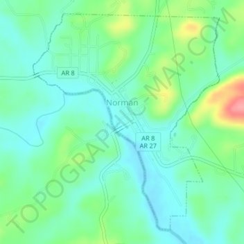
Name: Norman topographic map, elevation, terrain.

Location: Norman, Montgomery County, Arkansas, 71960, United States (34.44248 -93.69358 34.46648 -93.66851)

Average elevation: 227 m

Minimum elevation: 201 m

Maximum elevation: 294 m

Other topographic maps

Click on a map to view its topography, its elevation and its terrain.

Story

United States > Arkansas > Montgomery County

Average elevation: 220 m

Joplin

United States > Arkansas > Montgomery County

Average elevation: 231 m

Caddo Gap

United States > Arkansas > Montgomery County

Average elevation: 227 m

Gear up for your next adventure:

💧Hydration Pack - Hands-free hydration system for long hikes
🥾Durable Hiking Shoes - Long-lasting shoes for frequent hiking
Lightweight Backpacking Tent - Compact tent for efficient hiking trips
🔦UV Flashlight - Detect minerals or specific insects in the dark
🛏️Sleeping Bag - Warm and compact sleeping bags for outdoor camping

As an Amazon Associate, this site earns from qualifying purchases at no extra cost to you.