Geolocate

Vitznau topographic map

Click on the map to display elevation.

About this map

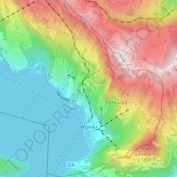
Name: Vitznau topographic map, elevation, terrain.

Location: Vitznau, Lucerne, 6354, Switzerland (46.99555 8.45847 47.04313 8.51405)

Average elevation: 907 m

Minimum elevation: 427 m

Maximum elevation: 1,671 m

Other topographic maps

Click on a map to view its topography, its elevation and its terrain.

Hämikon

Switzerland > Lucerne

Average elevation: 671 m

Alpach

Switzerland > Lucerne > Escholzmatt-Marbach > Escholzmatt

Average elevation: 966 m

Hellbühl

Switzerland > Lucerne

Average elevation: 639 m

Sörenberg

Switzerland > Lucerne

Average elevation: 1,386 m

Marbachegg

Switzerland > Lucerne > Escholzmatt-Marbach

Average elevation: 1,159 m

Gunzwil

Switzerland > Lucerne

Average elevation: 671 m

Schiltalp

Switzerland > Lucerne > Kriens

Average elevation: 962 m

Schloss Meggenhorn

Switzerland > Lucerne > Meggen

Average elevation: 450 m

Allmendhubel

Switzerland > Lucerne > Menznau

Average elevation: 636 m

Schachen

Switzerland > Lucerne > Werthenstein > Schachen

Average elevation: 671 m

Gear up for your next adventure:

🥾Trail Hiking Shoes - Durable shoes designed for rugged trails
🛶Kayak Accessories - Essential gear for safe and fun kayaking adventures
🧢Sun Hat - Wide-brim hat for sun protection
🔦LED Headtorch - Bright and durable light for night activities
🛁Quick-Dry Microfiber Towel - Space-saving towel that dries rapidly on the move

As an Amazon Associate, this site earns from qualifying purchases at no extra cost to you.