Geolocate

Canton topographic map

Click on the map to display elevation.

About this map

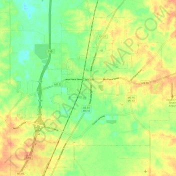
Name: Canton topographic map, elevation, terrain.

Location: Canton, Madison County, Mississippi, 39046, United States (32.56205 -90.09149 32.65304 -89.97298)

Average elevation: 75 m

Minimum elevation: 54 m

Maximum elevation: 95 m

Other topographic maps

Click on a map to view its topography, its elevation and its terrain.

Loring

United States > Mississippi > Madison County

Average elevation: 83 m

Canton

United States > Mississippi > Madison County > Canton

Average elevation: 74 m

Gear up for your next adventure:

🔦LED Headlamp - Hands-free lighting for early morning starts or late finishes
🛶Kayak Dry Bag - Waterproof storage for kayaking adventures
Lightweight Backpacking Tent - Compact tent for efficient hiking trips
🧴Bear Spray Holster - Quick-access carry for essential Canadian wilderness safety
🧦Outdoor Socks - Durable socks designed for hiking and outdoor sports

As an Amazon Associate, this site earns from qualifying purchases at no extra cost to you.