Geolocate

Canton topographic map

Click on the map to display elevation.

About this map

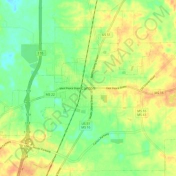
Name: Canton topographic map, elevation, terrain.

Location: Canton, Madison County, Mississippi, 39046, United States (32.57260 -90.07675 32.65260 -89.99675)

Average elevation: 74 m

Minimum elevation: 55 m

Maximum elevation: 92 m

Gear up for your next adventure:

👟Leg Gaiters - Keep debris, mud, and snow out of your boots
🪑Ultralight Camping Stool - Compact seating for rest stops during long hikes
🚲MTB Frame Bag - Carry tools and maps directly on your bicycle frame
🧢Hiking Sun Hat - Wide-brimmed protection for exposed mountain ridges
🧰Survival Kit - Essential gear for emergencies in the wilderness

As an Amazon Associate, this site earns from qualifying purchases at no extra cost to you.