
Make a donation
Gear up for your next adventure:
As an Amazon Associate, this site earns from qualifying purchases at no extra cost to you.
Sesapan Batu Rembau topographic map
Click on the map to display elevation.
Make a donation
Gear up for your next adventure:
As an Amazon Associate, this site earns from qualifying purchases at no extra cost to you.
About this map
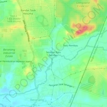
Name: Sesapan Batu Rembau topographic map, elevation, terrain.
Average elevation: 54 m
Minimum elevation: 28 m
Maximum elevation: 102 m
Make a donation
Gear up for your next adventure:
As an Amazon Associate, this site earns from qualifying purchases at no extra cost to you.
Other topographic maps
Click on a map to view its topography, its elevation and its terrain.
Make a donation
Gear up for your next adventure:
As an Amazon Associate, this site earns from qualifying purchases at no extra cost to you.
Make a donation
Gear up for your next adventure:
As an Amazon Associate, this site earns from qualifying purchases at no extra cost to you.
Make a donation
Gear up for your next adventure:
As an Amazon Associate, this site earns from qualifying purchases at no extra cost to you.
Sungai Sekamat
Malaysia > Selangor > Kajang Municipal Council > Kampung Sungai Sekamat
Average elevation: 40 m
Sungai Tekali
Malaysia > Selangor > Kajang Municipal Council > Batu 14 Hulu Langat
Average elevation: 79 m
Make a donation
Gear up for your next adventure:
As an Amazon Associate, this site earns from qualifying purchases at no extra cost to you.
Semungkis River
Malaysia > Selangor > Kajang Municipal Council > Batu 14 Hulu Langat
Average elevation: 186 m
Make a donation
Gear up for your next adventure:
As an Amazon Associate, this site earns from qualifying purchases at no extra cost to you.
Kampung Teras Jernang
Malaysia > Selangor > Kajang Municipal Council > Bangi Lama
Average elevation: 35 m
Semungkis River
Malaysia > Selangor > Kajang Municipal Council > Batu 14 Hulu Langat
Average elevation: 186 m
Make a donation
Gear up for your next adventure:
As an Amazon Associate, this site earns from qualifying purchases at no extra cost to you.
Make a donation
Gear up for your next adventure:
As an Amazon Associate, this site earns from qualifying purchases at no extra cost to you.
Bangi Wonderland Water Park
Malaysia > Selangor > Kajang Municipal Council > Bangi Lama
Average elevation: 42 m
Kampung Baru Balakong
Malaysia > Selangor > Kajang Municipal Council > Kampung Baru Balakong
Average elevation: 61 m
Make a donation
Gear up for your next adventure:
As an Amazon Associate, this site earns from qualifying purchases at no extra cost to you.
Sungai Sompo
Malaysia > Selangor > Kajang Municipal Council > Beranang > Kampung Tanjung
Average elevation: 43 m
Make a donation
Gear up for your next adventure:
As an Amazon Associate, this site earns from qualifying purchases at no extra cost to you.