
Lui River topographic map
Click on the map to display elevation.
About this map
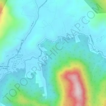
Name: Lui River topographic map, elevation, terrain.
Average elevation: 153 m
Minimum elevation: 66 m
Maximum elevation: 463 m
Other topographic maps
Click on a map to view its topography, its elevation and its terrain.
Bandar Baru Bangi
Malaysia > Selangor > Kajang Municipal Council > Bandar Baru Bangi
Average elevation: 47 m
Kampung Orang Asli Kuala Pangsun
Malaysia > Selangor > Kajang Municipal Council
Average elevation: 235 m
Kampung Sungai Semungkis
Malaysia > Selangor > Kajang Municipal Council > Batu 14 Hulu Langat
Average elevation: 85 m
Kampung Sungai Semungkis
Malaysia > Selangor > Kajang Municipal Council > Kampung Batu 16
Average elevation: 85 m