
Bangi Lama topographic map
Click on the map to display elevation.
About this map
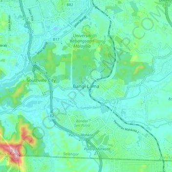
Name: Bangi Lama topographic map, elevation, terrain.
Average elevation: 46 m
Minimum elevation: -1 m
Maximum elevation: 254 m
Other topographic maps
Click on a map to view its topography, its elevation and its terrain.
Sungai Tekali
Malaysia > Selangor > Kajang Municipal Council > Batu 14 Hulu Langat
Average elevation: 79 m
Kampung Teras Jernang
Malaysia > Selangor > Kajang Municipal Council > Bangi Lama
Average elevation: 35 m
Sungai Sekamat
Malaysia > Selangor > Kajang Municipal Council > Kampung Sungai Sekamat
Average elevation: 40 m
Semungkis River
Malaysia > Selangor > Kajang Municipal Council > Batu 14 Hulu Langat
Average elevation: 186 m
Ramal River
Malaysia > Selangor > Kajang Municipal Council > Kampung Bukit Angkat
Average elevation: 41 m
Semungkis River
Malaysia > Selangor > Kajang Municipal Council > Batu 14 Hulu Langat
Average elevation: 186 m
Bangi Wonderland Water Park
Malaysia > Selangor > Kajang Municipal Council > Bangi Lama
Average elevation: 42 m
Kampung Baru Balakong
Malaysia > Selangor > Kajang Municipal Council > Kampung Baru Balakong
Average elevation: 61 m
Sungai Sompo
Malaysia > Selangor > Kajang Municipal Council > Beranang > Kampung Tanjung
Average elevation: 43 m