Geolocate

Siak topographic map

Click on the map to display elevation.

About this map

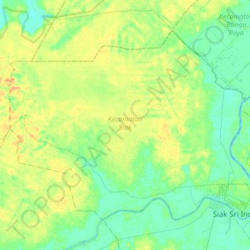
Name: Siak topographic map, elevation, terrain.

Location: Siak, Riau, Sumatra, Indonesia (0.78897 101.81880 0.97792 102.06669)

Average elevation: 12 m

Minimum elevation: -2 m

Maximum elevation: 33 m

Other topographic maps

Click on a map to view its topography, its elevation and its terrain.

Perawang

Indonesia > Riau > Siak

Average elevation: 12 m

Maredan

Indonesia > Riau > Siak

Average elevation: 7 m

Minas Barat

Indonesia > Riau > Siak

Average elevation: 64 m

Minas Jaya

Indonesia > Riau > Siak

Average elevation: 68 m

Siak Sri Indrapura

Indonesia > Riau > Siak

Average elevation: 5 m

Gear up for your next adventure:

🧥Packable Rain Jacket - Breathable waterproof layer for unpredictable weather
🧴Waterproofing Spray - Restore the DWR coating on jackets and tents
🪑Ultralight Camping Stool - Compact seating for rest stops during long hikes
🔦LED Headlamp - Hands-free lighting for early morning starts or late finishes
🕶️Polarized Sunglasses - Reduces glare from snow and water at high elevations

As an Amazon Associate, this site earns from qualifying purchases at no extra cost to you.