Geolocate

Perawang topographic map

Click on the map to display elevation.

About this map

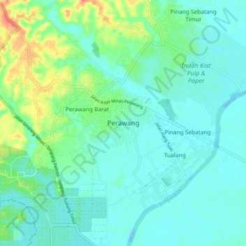
Name: Perawang topographic map, elevation, terrain.

Location: Perawang, Tualang, Siak, Riau, Sumatra, Indonesia (0.62533 101.56242 0.70533 101.64242)

Average elevation: 12 m

Minimum elevation: -1 m

Maximum elevation: 49 m

Other topographic maps

Click on a map to view its topography, its elevation and its terrain.

Minas

Indonesia > Riau > Siak

Average elevation: 31 m

Siak Sri Indrapura

Indonesia > Riau > Siak

Average elevation: 5 m

Kandis

Indonesia > Riau > Siak

Average elevation: 25 m

Bunga Raya

Indonesia > Riau > Siak

Average elevation: 9 m

Siak

Indonesia > Riau > Siak

Average elevation: 12 m

Minas

Indonesia > Riau > Siak

Average elevation: 31 m

Tualang

Indonesia > Riau > Siak

Average elevation: 21 m

Kandis

Indonesia > Riau > Siak

Average elevation: 25 m

Gear up for your next adventure:

🦟Insect Repellent - Keep mosquitoes and black flies away in wooded areas
👟Leg Gaiters - Keep debris, mud, and snow out of your boots
🥾Trail Hiking Boots - Supportive boots for rough trails
Bushcraft Tarp - Versatile emergency shelter or gear protection
🧢Hiking Hat - Sun-protective and breathable hats for long treks

As an Amazon Associate, this site earns from qualifying purchases at no extra cost to you.