Geolocate

Maredan topographic map

Click on the map to display elevation.

About this map

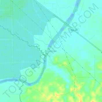
Name: Maredan topographic map, elevation, terrain.

Location: Maredan, Tualang, Siak, Riau, Sumatra, Indonesia (0.58910 101.57454 0.62910 101.61454)

Average elevation: 7 m

Minimum elevation: -2 m

Maximum elevation: 26 m

Other topographic maps

Click on a map to view its topography, its elevation and its terrain.

Minas

Indonesia > Riau > Siak

Average elevation: 31 m

Siak Sri Indrapura

Indonesia > Riau > Siak

Average elevation: 5 m

Kandis

Indonesia > Riau > Siak

Average elevation: 25 m

Bunga Raya

Indonesia > Riau > Siak

Average elevation: 9 m

Siak

Indonesia > Riau > Siak

Average elevation: 12 m

Minas

Indonesia > Riau > Siak

Average elevation: 31 m

Tualang

Indonesia > Riau > Siak

Average elevation: 21 m

Kandis

Indonesia > Riau > Siak

Average elevation: 25 m

Gear up for your next adventure:

💧Reusable Water Bottle - Durable water bottles for hydration on trails
💡LED Camping Lantern - Illuminate your campsite with long-lasting lanterns
🥾Approach Shoes - Shoes designed for climbing approaches and rugged trails
🧥Fleece Jacket - Warm and lightweight jacket for layering
🧴Outdoor Sunscreen - High SPF protection for high-altitude UV exposure

As an Amazon Associate, this site earns from qualifying purchases at no extra cost to you.