Geolocate

Uña topographic map

Click on the map to display elevation.

About this map

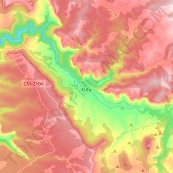
Name: Uña topographic map, elevation, terrain.

Location: Uña, Cuenca, Castile-La Mancha, Spain (40.19099 -2.04370 40.25854 -1.92008)

Average elevation: 1,325 m

Minimum elevation: 1,024 m

Maximum elevation: 1,526 m

Other topographic maps

Click on a map to view its topography, its elevation and its terrain.

Río Guadiana

Spain > Castile-La Mancha > La Mancha > Daimiel

Average elevation: 617 m

sinkhole

Spain > Castile-La Mancha > Pajarón

Average elevation: 1,042 m

Gear up for your next adventure:

🔪Outdoor Multitool - Versatile tool for repairs and food prep in the wild
🧤Thermal Hiking Gloves - Grip-enhanced gloves for cold-weather altitude trekking
🦶Hiking Shoe Insoles - Added support for high arches and long days on feet
🥾Waterproof Hiking Boots - Boots keeping your feet dry in wet conditions
🥾Mountain Hiking Boots - High-traction boots for rocky terrain

As an Amazon Associate, this site earns from qualifying purchases at no extra cost to you.