Geolocate

Morrison topographic map

Click on the map to display elevation.

About this map

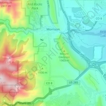
Name: Morrison topographic map, elevation, terrain.

Location: Morrison, Jefferson County, Colorado, 80465, United States (39.61748 -105.22206 39.66738 -105.16243)

Average elevation: 1,892 m

Minimum elevation: 1,708 m

Maximum elevation: 2,357 m

Other topographic maps

Click on a map to view its topography, its elevation and its terrain.

Genesee

United States > Colorado > Jefferson County > Golden

Average elevation: 2,249 m

Arvada

United States > Colorado > Jefferson County

Average elevation: 1,665 m

Gear up for your next adventure:

🥾Approach Boots - Comfortable boots for hiking and climbing approaches
🧥Softshell Jacket - Windproof and breathable jacket for hiking
🛶Canoe Life Vest - Safety vest for water sports
🧥Thermal Layer - Insulating layer for cold outdoor conditions
🧤Rechargeable Heated Gloves - Extreme warmth for Canadian winter expeditions

As an Amazon Associate, this site earns from qualifying purchases at no extra cost to you.