Geolocate

Hove topographic map

Click on the map to display elevation.

About this map

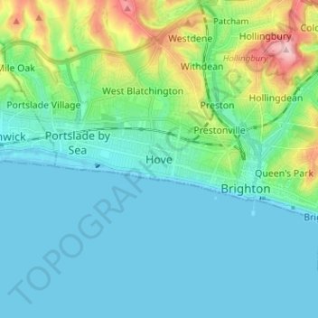
Name: Hove topographic map, elevation, terrain.

Location: Hove, Brighton and Hove, England, BN3 2AD, United Kingdom (50.78869 -0.21457 50.86869 -0.13457)

Average elevation: 35 m

Minimum elevation: -1 m

Maximum elevation: 178 m

Other topographic maps

Click on a map to view its topography, its elevation and its terrain.

Brighton

United Kingdom > England > Brighton and Hove

Average elevation: 64 m

Hove Park

United Kingdom > England > Brighton and Hove > Hove

Average elevation: 53 m

Hove

United Kingdom > England > Brighton and Hove

Average elevation: 54 m

BN2 4PG

United Kingdom > England > Brighton and Hove > Brighton

Average elevation: 93 m

BN2 0QU

United Kingdom > England > Brighton and Hove > Brighton

Average elevation: 44 m

Gear up for your next adventure:

🛏️Camping Sleeping Mat - Comfortable mats for sleeping outdoors
🔋Emergency Crank Radio - Weather alerts and power without needing batteries
🏃Hydration Running Vest - Carry water and maps close to your body for speed
🧥Waterproof Jacket - Lightweight rain jackets for hiking and outdoor activities
🦯Trekking Poles - Reduced impact on joints for steep topographic climbs

As an Amazon Associate, this site earns from qualifying purchases at no extra cost to you.