Geolocate

Hestra topographic map

Click on the map to display elevation.

About this map

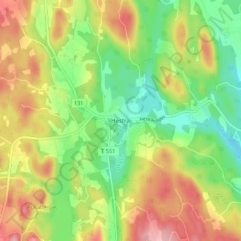
Name: Hestra topographic map, elevation, terrain.

Location: Hestra, Ydre kommun, Östergötland County, Sweden (57.93674 15.05407 57.97674 15.09407)

Average elevation: 215 m

Minimum elevation: 155 m

Maximum elevation: 287 m

Other topographic maps

Click on a map to view its topography, its elevation and its terrain.

Kinda kommun

Sweden > Östergötland County

Average elevation: 133 m

Navestad

Sweden > Östergötland County > Norrköping

Average elevation: 34 m

Vadstena

Sweden > Östergötland County

Average elevation: 98 m

Illern

Sweden > Östergötland County > Linköping

Average elevation: 72 m

Nässja

Sweden > Östergötland County

Average elevation: 91 m

Halgen

Sweden > Östergötland County

Average elevation: 88 m

Mjölby kommun

Sweden > Östergötland County

Average elevation: 123 m

Boxholms kommun

Sweden > Östergötland County

Average elevation: 169 m

Järstad

Sweden > Östergötland County

Average elevation: 82 m

Gear up for your next adventure:

🛌Insulated Sleeping Pad - Critical thermal barrier between you and the cold ground
🔋Lithium AA Batteries - Long-lasting power that performs in extreme cold
🛶Waterproof Dry Bags - Keep electronics and clothes dry during river crossings
🥾Waterproof Hiking Boots - Boots keeping your feet dry in wet conditions
🗺️Topographic Maps - Detailed maps to explore trails, mountains, and wilderness areas

As an Amazon Associate, this site earns from qualifying purchases at no extra cost to you.