Geolocate

Cartersburg topographic map

Click on the map to display elevation.

About this map

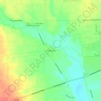
Name: Cartersburg topographic map, elevation, terrain.

Location: Cartersburg, Hendricks County, Indiana, United States (39.67866 -86.48361 39.71866 -86.44361)

Average elevation: 242 m

Minimum elevation: 218 m

Maximum elevation: 271 m

Other topographic maps

Click on a map to view its topography, its elevation and its terrain.

North Salem

United States > Indiana > Hendricks County

Average elevation: 278 m

Stilesville

United States > Indiana > Hendricks County

Average elevation: 240 m

Coatesville

United States > Indiana > Hendricks County

Average elevation: 271 m

Pittsboro

United States > Indiana > Hendricks County

Average elevation: 285 m

Amo

United States > Indiana > Hendricks County

Average elevation: 255 m

Avon

United States > Indiana > Hendricks County

Average elevation: 254 m

Danville

United States > Indiana > Hendricks County

Average elevation: 281 m

Clayton

United States > Indiana > Hendricks County

Average elevation: 263 m

Lizton

United States > Indiana > Hendricks County

Average elevation: 292 m

Gear up for your next adventure:

🪑Insulated Seat Pad - Protect your seat from cold rocks and wet logs
🧥Softshell Hiking Jacket - The perfect balance of wind protection and breathability
🧣Merino Neck Gaiter - Protects against wind, sun, and cold at high altitudes
🥾Durable Hiking Shoes - Long-lasting shoes for frequent hiking
🦟Insect Repellent - Keep mosquitoes and black flies away in wooded areas

As an Amazon Associate, this site earns from qualifying purchases at no extra cost to you.