
Delhi topographic map
Click on the map to display elevation.
Delhi
The topography of the medieval fort Purana Qila on the banks of the river Yamuna matches the literary description of the citadel Indraprastha in the Sanskrit epic Mahabharata; however, excavations in the area have revealed no signs of an ancient built environment. From the early 13th century until the mid-19th century, Delhi was the capital of two major empires, the Delhi Sultanate and the Mughal Empire, which covered large parts of South Asia. All three UNESCO World Heritage Sites in the city, the Qutub Minar, Humayun's Tomb, and the Red Fort, belong to this period. Delhi was the early centre of Sufism and Qawwali music. The names of Nizamuddin Auliya and Amir Khusrau are prominently associated with it. The Khariboli dialect of Delhi was part of a linguistic development that gave rise to the literature of Urdu and later Modern Standard Hindi. Major Urdu poets from Delhi include Mir Taqi Mir and Mirza Ghalib. Delhi was a notable centre of the Indian Rebellion of 1857. In 1911, New Delhi, a southern region within Delhi, became the capital of the British Indian Empire. During the Partition of India in 1947, Delhi was transformed from a Mughal city to a Punjabi one, losing two-thirds of its Muslim residents, in part due to the pressure brought to bear by arriving Hindu and Sikh refugees from western Punjab. After independence in 1947, New Delhi continued as the capital of the Dominion of India, and after 1950 of the Republic of India.
About this map
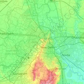
Name: Delhi topographic map, elevation, terrain.
Location: Delhi, India (28.40463 76.83884 28.88345 77.34525)
Average elevation: 218 m
Minimum elevation: 192 m
Maximum elevation: 315 m
Other topographic maps
Click on a map to view its topography, its elevation and its terrain.
Surat
India > Gujarat > Katargam Taluka > Surat
Surat is a port city situated on the banks of the Tapi river. Damming of the Tapi caused the original port facilities to close; the nearest port is now in the Magadalla and Hazira area of Surat Metropolitan Region.It has famous beach called 'Dumas Beach' located in Hazira. The city is located at 21°10′N…
Average elevation: 11 m
Junagadh
India > Gujarat > Junagadh City Taluka
Junagadh city is located at 21°31′N 70°28′E / 21.52°N 70.47°E / 21.52; 70.47 at the foot of Mount Girnar, with the Arabian sea to the southwest, Porbandar to the north, and Amreli to the east. It has an average elevation of 107 metres (351 ft).
Average elevation: 163 m
Ayodhya
India > Uttar Pradesh > Faizabad
The earliest of the Buddhist Pali-language texts and the Jain Prakrit-language texts mention a city called Saketa (Sageya or Saeya in Prakrit) as an important city of the Kosala mahajanapada. Topographical indications in both Buddhist and Jain texts suggest that Saketa is the same as the present-day Ayodhya.…
Average elevation: 96 m
Varanasi
India > Uttar Pradesh > Sadar
Varanasi is located at an elevation of 80.71 metres (264.8 ft) in the centre of the Ganges valley of North India, in the Eastern part of the state of Uttar Pradesh, along the left crescent-shaped bank of the Ganges, averaging between 15 metres (50 ft) and 21 metres (70 ft) above the river. The city is the…
Average elevation: 77 m
Udaipur
India > Rajasthan > Girwa Tehsil
Udaipur is located at 24°31′30″N 73°40′38″E / 24.525049°N 73.677116°E / 24.525049; 73.677116. The city covers an area of 64 km2 (25 sq mi) and lies at an altitude of 598.00 m (1,962 ft) above sea level. It is located in the southern region of Rajasthan, near the Gujarat border. The city…
Average elevation: 656 m
Guwahati
Professor Abani Kumar Bhagawati of Gauhati University stated that since before there were sufficient wetlands to absorb rainwater and channels to carry excess water to the Brahmaputra, the city did not experience floods. However, human interference has disrupted the natural topography, leading to the current…
Average elevation: 113 m
Jammu
India > Jammu and Kashmir > Jammu
Jammu is located at 32°44′N 74°52′E / 32.73°N 74.87°E / 32.73; 74.87. It has an average elevation of 300 m (980 ft). Jammu city lies at uneven ridges of low heights at the Shivalik hills. It is surrounded by the Shivalik range to the north, east, and southeast while the Trikuta Range surrounds…
Average elevation: 367 m
Navi Mumbai
India > Maharashtra > Thane > Navi Mumbai
Navi Mumbai (Marathi pronunciation: , also known by its former name New Bombay), is a planned city off the west coast of the Indian state of Maharashtra in Konkan division. The city is divided into two parts, North Navi Mumbai and South Navi Mumbai, for the individual development of Panvel Mega City, which…
Average elevation: 30 m
Kapadvanj
India > Gujarat > Kapadvanj Taluka
Kapadvanj is located at 23°01′N 73°04′E / 23.02°N 73.07°E / 23.02; 73.07. It has an average elevation of 69 metres (226 feet).
Average elevation: 77 m
Shimla
Shimla is on the south-western ranges of the Himalayas at 31°37′N 77°06′E / 31.61°N 77.10°E / 31.61; 77.10. It has an average altitude of 2,206 metres (7,238 ft) above mean sea level and extends along a ridge with seven spurs. The city stretches nearly 9.2 kilometres (5.7 mi) from east to west.
Average elevation: 1,557 m
Patna
India > Bihar > Patna Rural
Patna is on the southern bank of the river Ganges. The total area of Patna is 250 km2 (97 sq mi). Of this, the municipal area constitutes 109.218 km2 (42.169 sq mi). The suburban area covers 140.782 km2 (54.356 sq mi). It has an average elevation of 53 m (174 ft). A characteristic feature of the geography of…
Average elevation: 51 m
Varanasi
India > Uttar Pradesh > Sadar
Varanasi is located at an elevation of 80.71 metres (264.8 ft) in the centre of the Ganges valley of North India, in the Eastern part of the state of Uttar Pradesh, along the left crescent-shaped bank of the Ganges, averaging between 15 metres (50 ft) and 21 metres (70 ft) above the river. The city is the…
Average elevation: 77 m
Vellore
India > Tamil Nadu > Vellore
Vellore is at 12°55′N 79°08′E / 12.92°N 79.13°E / 12.92; 79.13, 220m above sea level. The city has a tropical savanna climate. It is in the Vellore district of the South Indian state, Tamil Nadu, 135 km (84 mi) west of the state capital Chennai and 30 km (19 mi) kms South of its twin city…
Average elevation: 283 m
Jolarpet
India > Tamil Nadu > Tirupathur
Jolarpet is a second grade municipality in Tirupattur district. Jolarpet is renowned for its railway station. The town is also located on State Highway 18 connecting Vaniyambadi -Tirupattur. Regarding transportation linkage, the highway (NH 48) from Chennai to Krishnagiri passes through the outskirts of the…
Average elevation: 493 m
Bhusawal
Bhusawal is located at 21°02'50.56"N 75°47'15.99"E. It has an average elevation of 209 metres. The city lies on the banks of the Tapi River, falling in the valley between the Satpura ranges and the Ajanta hills of the Deccan Plateau. The total land area of the municipal council is 228.57 km2.
Average elevation: 230 m
Maharashtra
Maharashtra is the third largest state by area in India. The Western Ghats better known as Sahyadri, are a hilly range running parallel to the coast, at an average elevation of 1,200 metres (4,000 ft). Kalsubai, a peak in the Sahyadris, near Nashik city is the highest elevated point in Maharashtra. To the west…
Average elevation: 478 m
Bokaro
Bokaro district consists of undulating uplands on the Chota Nagpur Plateau with the Damodar River cutting a valley right across. It has an average elevation of 200 to 540 metres (660 to 1,770 ft) above mean sea level. The highest hill, Lugu Pahar, rises to a height of 1,070 metres (3,510 ft). The East Bokaro…
Average elevation: 232 m
Kohima
India > Nagaland > Kohima Sadar
Kohima (/koʊˈhiːmə/ ; Angami Naga: Kewhira (IPA: [ˈkɛʍɪɻə]) is the capital of the Indian state of Nagaland. With a resident population of almost 100,000, it is the second largest city in the state. Kohima constitutes both a district and a municipality. The municipality covers 20 km2 (7.7 sq mi). The…
Average elevation: 1,425 m
Cuddalore
India > Tamil Nadu > Cuddalore
Cuddalore is located at 11°45′N 79°45′E / 11.75°N 79.75°E / 11.75; 79.75. It has an average elevation of 6 m (20 ft). The land is completely flat with large deposits of black and alluvial soil inland and coarse sand near the seashore. The sandstone deposits in the town are popular. The…
Average elevation: 8 m
Kolkata
Spread roughly north–south along the east bank of the Hooghly River, Kolkata sits within the lower Ganges Delta of eastern India approximately 75 km (47 mi) west of the international border with Bangladesh; the city's elevation is 1.5–9 m (5–30 ft). Much of the city was originally a wetland that was…
Average elevation: 5 m
Mumbai
Mumbai lies at the mouth of the Ulhas River on the western coast of India, in the coastal region known as the Konkan. It sits on Salsette Island (Sashti Island), which it partially shares with the Thane district. Mumbai is bounded by the Arabian Sea to the west. Many parts of the city lie just above sea level,…
Average elevation: 13 m
Tirunelveli
India > Tamil Nadu > Palayamkottai
Tirunelveli is located at 8°43′41.82″N 77°41′43.94″E / 8.7282833°N 77.6955389°E / 8.7282833; 77.6955389, and its average elevation is 47 metres (154 ft). It is located at the southernmost tip of the Deccan plateau. The Tamirabarani River divides the city into the Tirunelveli quarter and…
Average elevation: 34 m
Warangal
India > Telangana > Warangal mandal
Warangal is located at 18°00′N 79°35′E / 18.0°N 79.58°E / 18.0; 79.58. It has an average elevation of 302 metres (990 feet). It is settled in the eastern part of Deccan Plateau made up of granite rocks and hill formations which left the region barren making the cultivation dependent on…
Average elevation: 268 m
Manipal
India > Karnataka > Udupi taluku
Manipal is a suburb and university town within Udupi, in coastal Karnataka, India. Manipal is located five kilometres away from the centre of Udupi City, in Udupi District, Karnataka (state) in south western India. It is administered by the Udupi City Municipality. The suburb is located in coastal Karnataka,…
Average elevation: 32 m
Dehradun
India > Uttarakhand > Dehradun
The city of Dehradun mainly lies in Doon Valley and is at a varying height from 410 m (1,350 ft) in Clement Town to above 700 m (2,300 ft) at Malsi which is 15 km (9.3 mi) from the city. However, the average elevation is 450 m (1,480 ft) above sea level. Malsi is the starting point of Lesser Himalayan Range…
Average elevation: 904 m
Ranchi
Ranchi lies at 23°22′N 85°20′E / 23.36°N 85.33°E / 23.36; 85.33 near to the Tropic of Cancer. The city covers an area of 175 km2 (68 sq mi) and its average elevation is 651 m above sea level. Ranchi is located in the southern part of the Chota Nagpur plateau, which is the eastern section of…
Average elevation: 648 m
Bhowali
India > Uttarakhand > Nainital
Bhowali (Kumaoni: Bhoāli)[bʱəʋaːli] is a town and municipal board in Nainital District in the state of Uttarakhand, India. It is situated at a distance of 11 km (6.8 mi) from the city of Nainital, the district headquarters; at an average elevation of 1,654 m (5,427 ft) from sea level. It is the seat of…
Average elevation: 1,672 m
Pithoragarh
India > Uttarakhand > Pithoragarh Tehsil
Pithoragarh is located at 29°35′N 80°13′E / 29.58°N 80.22°E / 29.58; 80.22. in the district of Pithoragarh, Uttarakhand, India. It lies in the revenue Division of Kumaon and is located 188 km northeast of Nainital, the administrative headquarters of Kumaon. It has an average elevation of 1,627…
Average elevation: 1,617 m
Erattupetta
It has an average elevation of 36 metres (118 feet).
Average elevation: 78 m
Thrissur
Thrissur is the headquarters of Thrissur district, in the centre of the Indian state of Kerala. The city is 75 km north-east of Kochi, 133 km south-west of Coimbatore, 124 km south-east of Kozhikode and 151 km north of Changanacherry. The city is located in a hillock called Thekkinkadu Maidan which is the…
Average elevation: 36 m
Udaipur
India > Rajasthan > Girwa Tehsil
Udaipur is located at 24°31′30″N 73°40′38″E / 24.525049°N 73.677116°E / 24.525049; 73.677116. The city covers an area of 64 km2 (25 sq mi) and lies at an altitude of 598.00 m (1,962 ft) above sea level. It is located in the southern region of Rajasthan, near the Gujarat border. The city…
Average elevation: 656 m
Nainital
India > Uttarakhand > Nainital
The city of Nainital covers a total area of 11.73 km2 (4.53 sq mi), and is located at 29°23′N 79°27′E / 29.38°N 79.45°E / 29.38; 79.45, at an average elevation of 2,084 metres (6,837 ft) above sea level. The slopes of the nearby mountains are most populated, with an elevation ranging from…
Average elevation: 1,813 m
Salem
Salem is located at 11°40′N 78°08′E / 11.67°N 78.14°E / 11.67; 78.14, at an average elevation of 278 m (912 ft). The city is surrounded by hills: Nagaramalai on the north, Jarugumalai on the south, Kanjamalai on the west, Godumalai on the east and the Shevaroy Hills on the northeast.…
Average elevation: 418 m
Bengaluru
India > Karnataka > Bangalore North
Bengaluru lies in the southeast of the South Indian state of Karnataka in the heart of the Mysore Plateau (a region of the larger Deccan Plateau) at an average elevation of 900 m (2,953 ft). The city covers an area of 741 km2 (286 sq mi). The Bengaluru metropolitan region covers an area of 7,005 km2 (2,705 sq…
Average elevation: 879 m