Geolocate

Erattupetta topographic map

Click on the map to display elevation.

Erattupetta

It has an average elevation of 36 metres (118 feet).

Wikipedia (CC-BY-SA 3.0)

About this map

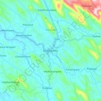
Name: Erattupetta topographic map, elevation, terrain.

Location: Erattupetta, Meenachil, Kottayam District, Kerala, 686122, India (9.64799 76.73977 9.72799 76.81977)

Average elevation: 78 m

Minimum elevation: 10 m

Maximum elevation: 415 m

Gear up for your next adventure:

🧼Biodegradable Camp Soap - Environmentally friendly cleaning for gear and body
🚲Heavy Duty Bike Lock - Secure your bike at the trailhead or during stops
🧢Outdoor Visor - Breathable visor for sunny hikes
🧦Crew Hiking Socks - Comfortable socks for long-distance hikes
Camping Coffee Maker - Brew fresh coffee anywhere on the topographic map

As an Amazon Associate, this site earns from qualifying purchases at no extra cost to you.