Geolocate

Konni topographic map

Click on the map to display elevation.

About this map

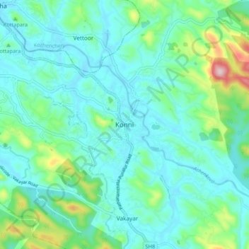
Name: Konni topographic map, elevation, terrain.

Location: Konni, Pathanamthitta, Kerala, 699691, India (9.18669 76.80995 9.26669 76.88995)

Average elevation: 78 m

Minimum elevation: 19 m

Maximum elevation: 321 m

Other topographic maps

Click on a map to view its topography, its elevation and its terrain.

Aruvappulam

India > Kerala > Konni

Average elevation: 519 m

Gurunathanmannu

India > Kerala > Konni

Average elevation: 724 m

Gear up for your next adventure:

🧢Sun Protection Cap - Breathable cap to protect from sun exposure
🥾Trail Hiking Socks - Comfortable socks to prevent blisters and fatigue
💧Filtered Water Bottle - Safe drinking water on the go
🧢Hiking Sun Hat - Wide-brimmed protection for exposed mountain ridges
🧥Packable Rain Jacket - Breathable waterproof layer for unpredictable weather

As an Amazon Associate, this site earns from qualifying purchases at no extra cost to you.