Geolocate

Junagadh topographic map

Click on the map to display elevation.

Junagadh

Junagadh city is located at 21°31′N 70°28′E / 21.52°N 70.47°E / 21.52; 70.47 at the foot of Mount Girnar, with the Arabian sea to the southwest, Porbandar to the north, and Amreli to the east. It has an average elevation of 107 metres (351 ft).

Wikipedia (CC-BY-SA 3.0)

About this map

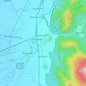
Name: Junagadh topographic map, elevation, terrain.

Location: Junagadh, Junagadh City Taluka, Junagadh District, Gujarat, 362015, India (21.48828 70.39396 21.54876 70.47842)

Average elevation: 163 m

Minimum elevation: 54 m

Maximum elevation: 853 m

Gear up for your next adventure:

🧥Softshell Hiking Jacket - The perfect balance of wind protection and breathability
🧥Waterproof Hiking Jacket - Protect yourself from rain and wind while hiking
🥾Trail Hiking Shoes - Durable shoes designed for rugged trails
💧Hydration Pack - Hands-free hydration system for long hikes
🥾Hiking Boots - Sturdy boots providing ankle support and traction on rugged trails

As an Amazon Associate, this site earns from qualifying purchases at no extra cost to you.