Geolocate

Cabanatuan topographic map

Click on the map to display elevation.

About this map

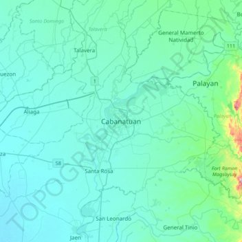
Name: Cabanatuan topographic map, elevation, terrain.

Location: Cabanatuan, Nueva Ecija, Central Luzon, 3100, Philippines (15.33050 120.80843 15.65050 121.12843)

Average elevation: 47 m

Minimum elevation: 10 m

Maximum elevation: 388 m

Other topographic maps

Click on a map to view its topography, its elevation and its terrain.

Palayan

Philippines > Nueva Ecija

Average elevation: 107 m

Llanera

Philippines > Nueva Ecija

Average elevation: 73 m

Quezon

Philippines > Nueva Ecija

Average elevation: 28 m

Gear up for your next adventure:

🧴Insect Repellent - Protect yourself from bugs during outdoor adventures
🛶Canoe Life Vest - Safety vest for water sports
🥘Camping Cookware Set - Compact nesting pots and pans for trail cooking
🚑Survival Whistle - Signal for help across long distances in mountains
Backpacking Tent - Lightweight tent for long-distance hiking trips

As an Amazon Associate, this site earns from qualifying purchases at no extra cost to you.