Geolocate

Palayan topographic map

Click on the map to display elevation.

About this map

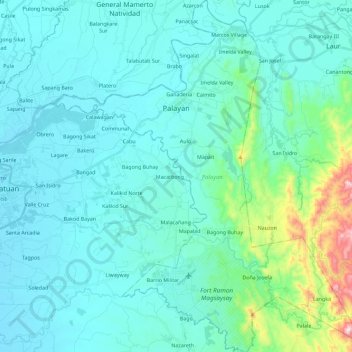
Name: Palayan topographic map, elevation, terrain.

Location: Palayan, Nueva Ecija, Central Luzon, Philippines (15.38760 121.00372 15.60826 121.20695)

Average elevation: 107 m

Minimum elevation: 28 m

Maximum elevation: 633 m

Other topographic maps

Click on a map to view its topography, its elevation and its terrain.

Cabanatuan

Philippines > Nueva Ecija

Average elevation: 47 m

Abar 1st

Philippines > Nueva Ecija

Average elevation: 105 m

Ciudad de Real

Philippines > Nueva Ecija > Cabanatuan

Average elevation: 36 m

Gapan

Philippines > Nueva Ecija

Average elevation: 34 m

Gear up for your next adventure:

🥾Trail Hiking Shoes - Durable shoes designed for rugged trails
🧦Crew Hiking Socks - Comfortable socks for long-distance hikes
🥾Light Trekking Boots - Supportive boots for multi-day treks
Camping Groundsheet - Protect your tent from moisture and dirt
🔦LED Headlamp - Hands-free lighting for early morning starts or late finishes

As an Amazon Associate, this site earns from qualifying purchases at no extra cost to you.